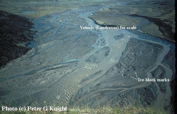
 View looking southwards past the terminus of the glacier
Solheimajokull, Iceland, from an adjacent hillside in 1990. The Landrover
parked on the river bank at the top right of the photo gives an indication
of scale. The proglacial area is marked by numerous ice-block scour marks
and kettle holes up to 5m in diameter and 2m deep. These are created by
fragments of glacier ice that become entrained in minor outbursts of water
and sediment from the glacier. The ice blocks affect the erosion and deposition
of sediment by the floodwaters, and then are either washed away in the
flow as they gradually melt, or melt away on the outwash plain after the
flood has subsided. The largest examples are highlighted in the lower right
of the photo, and others can be seen on the left of the photo nearer to
the glacier. The outbursts with which these features are associated can
occur for a variety of reasons, but in this case arose from the temporary
blockage and subsequent sudden release of water emerging from a tunnel
beneath the snout of the glacier. Volcanic activity can produce much larger
floods, but the extent of ice-block marking on the outwash plain
is controlled not not simply the size of the flood, but by a range
of factors including the sizes of the ice blocks produced by the glacier
and the concentration of debris in the floodwaters. Paradoxically, larger
(deeper) floods might produce less ice-block impact.
View looking southwards past the terminus of the glacier
Solheimajokull, Iceland, from an adjacent hillside in 1990. The Landrover
parked on the river bank at the top right of the photo gives an indication
of scale. The proglacial area is marked by numerous ice-block scour marks
and kettle holes up to 5m in diameter and 2m deep. These are created by
fragments of glacier ice that become entrained in minor outbursts of water
and sediment from the glacier. The ice blocks affect the erosion and deposition
of sediment by the floodwaters, and then are either washed away in the
flow as they gradually melt, or melt away on the outwash plain after the
flood has subsided. The largest examples are highlighted in the lower right
of the photo, and others can be seen on the left of the photo nearer to
the glacier. The outbursts with which these features are associated can
occur for a variety of reasons, but in this case arose from the temporary
blockage and subsequent sudden release of water emerging from a tunnel
beneath the snout of the glacier. Volcanic activity can produce much larger
floods, but the extent of ice-block marking on the outwash plain
is controlled not not simply the size of the flood, but by a range
of factors including the sizes of the ice blocks produced by the glacier
and the concentration of debris in the floodwaters. Paradoxically, larger
(deeper) floods might produce less ice-block impact.
Also note the confluence and parallel in-stream
flow of sediment-rich (grey) glacier meltwater and clear (blue) non-glacial
water immediately below the position of the landrover.
back to photo's index